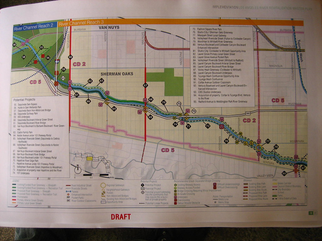
So I got a peek at the LA River Master plan today at the
Friends of the LA River tour (something I highly recommend) that took a group of about 30 people to 5 locations in LA on the river (Sepulveda Dam being one of them). You can
download it from the website, but I'm not a big fan of PDFs that are 100s of pages long.
Above is the Sherman Oaks/Studio City portion of the draft plan (click to enlarge and se it up close). Here are the ideas:
- The south side of the river (downstream) is a "Proposed River Greenway - Bike Path."
- The north side of the river (upstream) is a "Proposed River Greenway - Recreation Trail."
- The dashed turquoise lines mark "Riverside Streets" such as Valleyheart St. between Hazeltine and Woodman
- The yellow overlay signifies the "Green Corridor" and not City Council Boundries (which are marked by pink lines)
- The "U" in a pink box means Underpass, but the same marking with a bolded border means "Underpass difficulties." An example would be grading the ground for the path to go under the bridge could prove to be a very difficult project. Maybe a crossing with a light is the solution. The "O" stands for Overcrossing.
- The diamonds with numbers in them tell us where "Potential Projects" may go. The ones with black numbers on a white background signify "Proposed Projects extending into the community that may require the acquisition of private property." Sounds scary to owners, but here is a list of all land grab those projects:
- Number 63 is Castle Park, which the city already owns, so I am not sure what this is all about.
- Number 73 says "Acquisition of Property near Hazeltine and the River. I don't know if this means around the Sunkist Building (not going to happen) or the tow yard (could happen).
- Number 75 is very interesting - "Fashion Square River Park." Sounds like a nudge nudge wink wink corporate funding request for a park named after the mall.
- One of the other potential projects caught my eye: Hazeltine River Edge Park which would be between Van Nuys Blvd and Hazeltine between the river and the homes south of Riverside.
 I'm tempted to start this up, but I am way over-involved. But for this to happen would be incredible.
